One of the things we have enjoyed most in our exploration of New Zealand is the waterfalls. The country is as green as it is due to lots of rainfall, and the rain creates lots of streams and rivers. When those streams and rivers run through New Zealand’s many mountains and hills, the result is an amazing assortment of waterfalls.
The varied topography also creates lots of different types of waterfalls. To better appreciate the differences between types, we did a little research. Here’s a bit of what we learned:
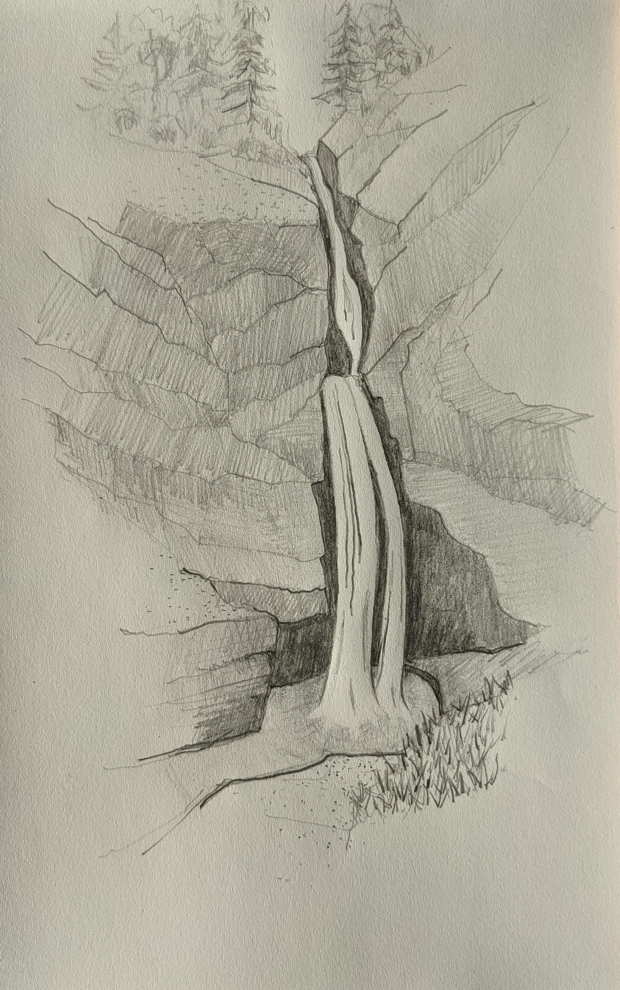 A horse-tail waterfall is a near vertical drop characterized by water maintaining constant or almost-constant contact with the underlying rock that it flows over. Unlike the fan, the width of the horse tail does not increase much from top to bottom, like a horse’s tail. |
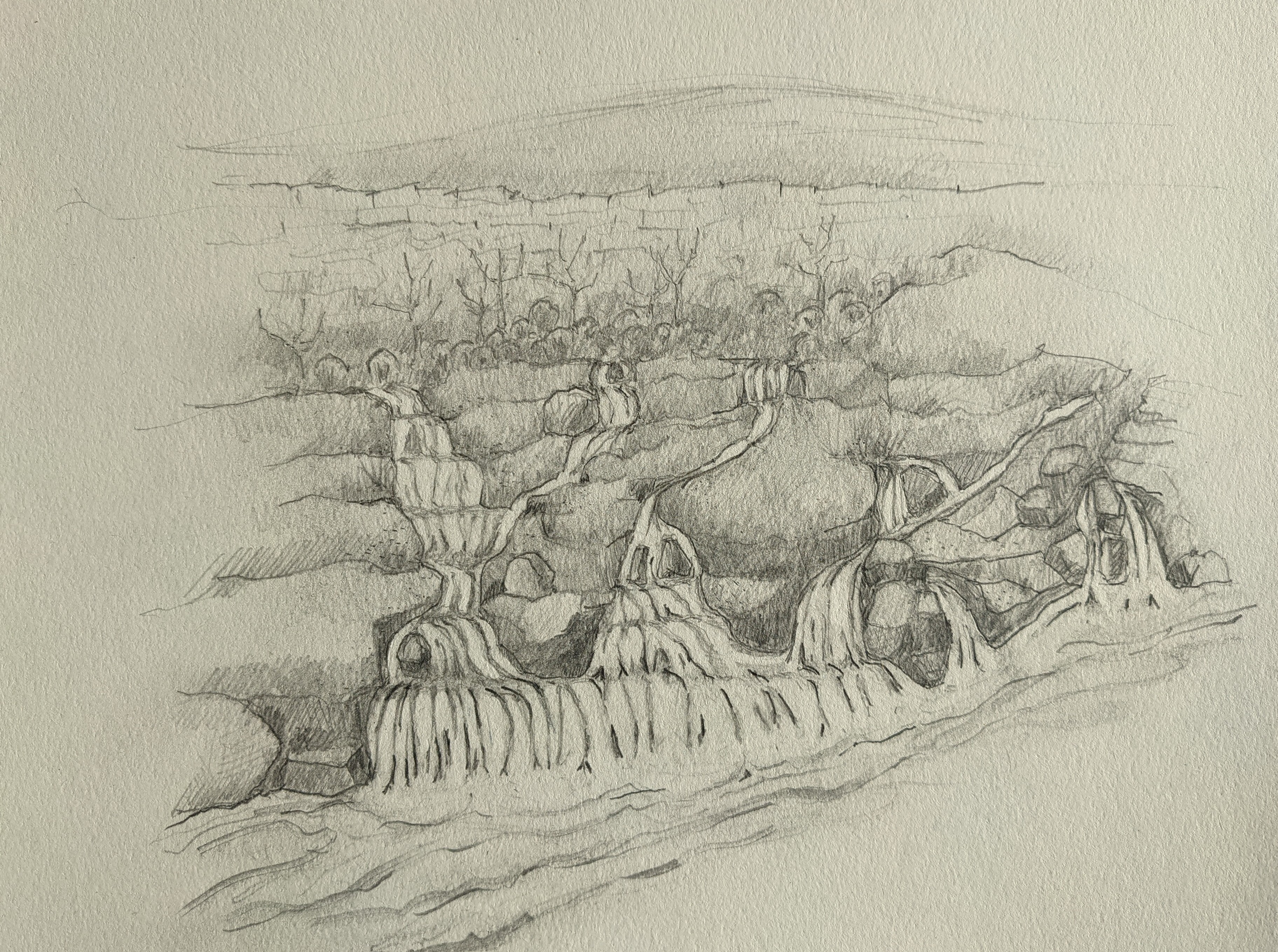
 In a plunge or curtain waterfall, the water flows vertically over a broad ledge, usually an overhanging one, into a pool without making contact with the underlying rock during its descent. Typically, plunge waterfalls also generate enough spray to further erode the underside of the cliff, creating alcoves or “caves” beneath the ledge. As a result, you can sometimes even go behind the watery curtain. |
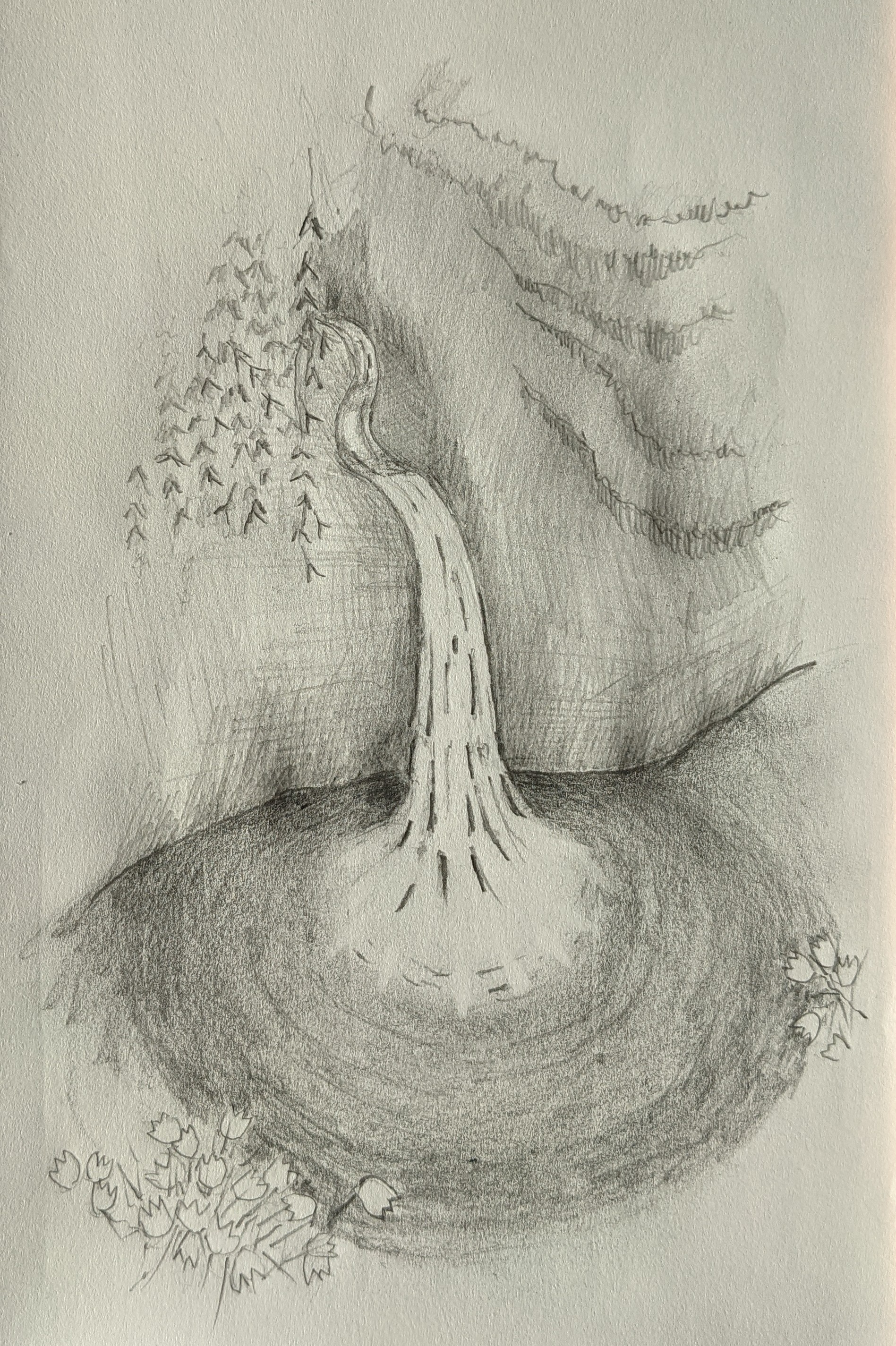 A punch bowl is a special type of plunge characterized by water being forced into a very constricted channel and then squeezed down into a pool. The pool is generally tranquil enough to safely allow for swimming. |
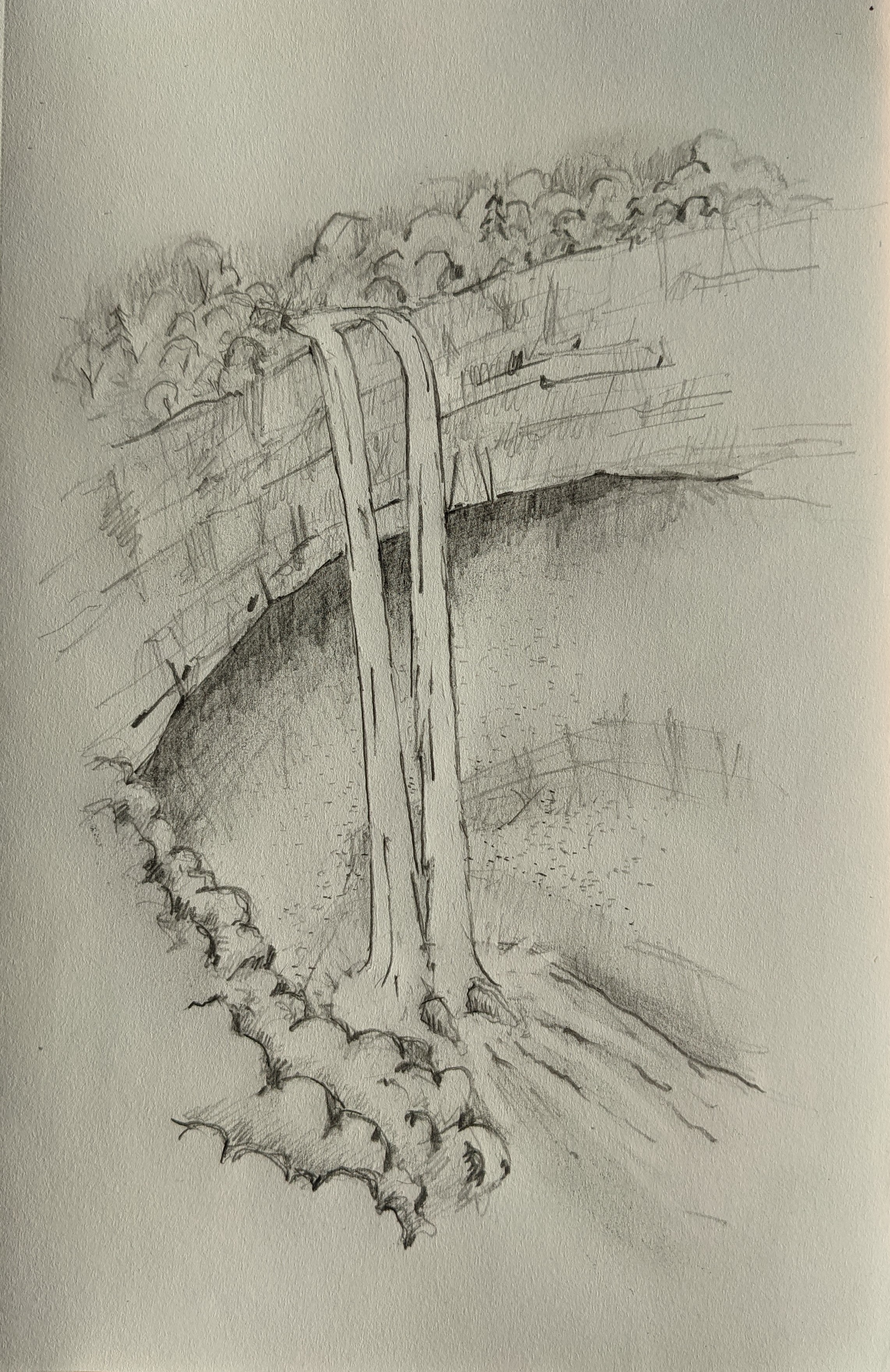
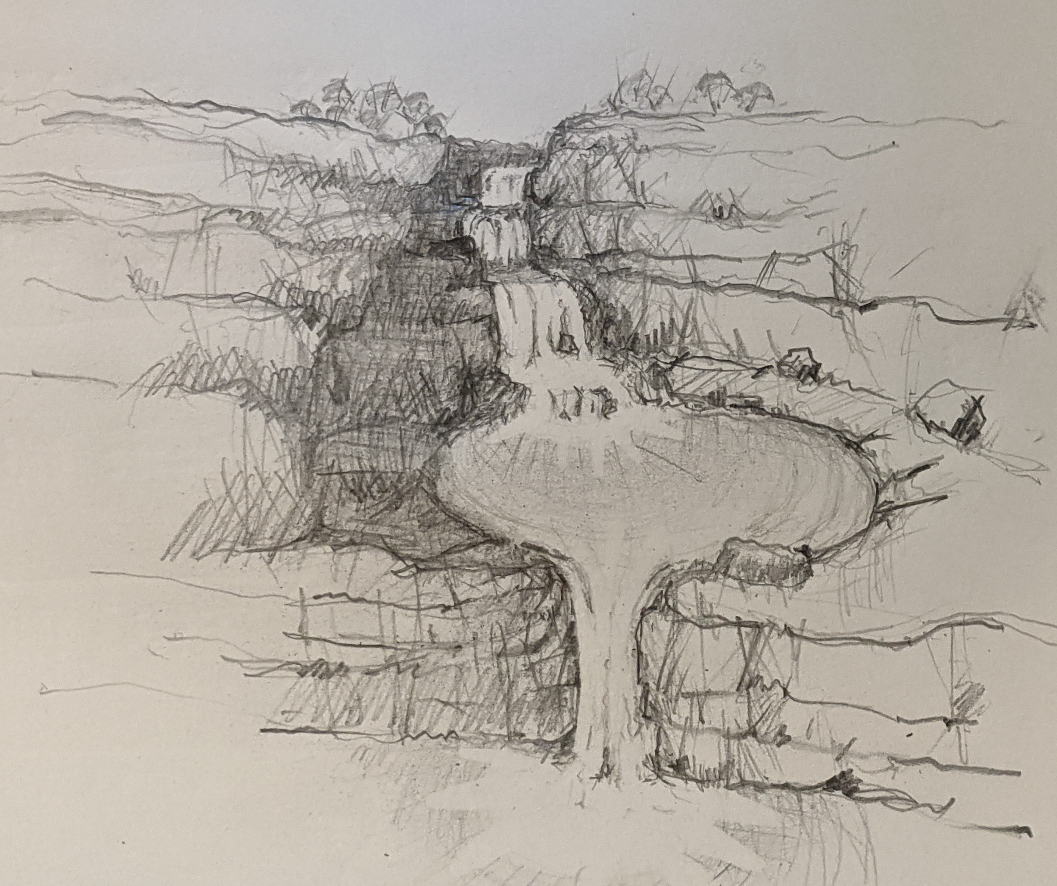 A multi-step or tiered waterfall consists of a series of waterfalls dropping consecutively from one level to another, with a pool at the bottom of each level or tier. The steps are definite enough to count, though not all may be visible to the observer from one vantage point. |
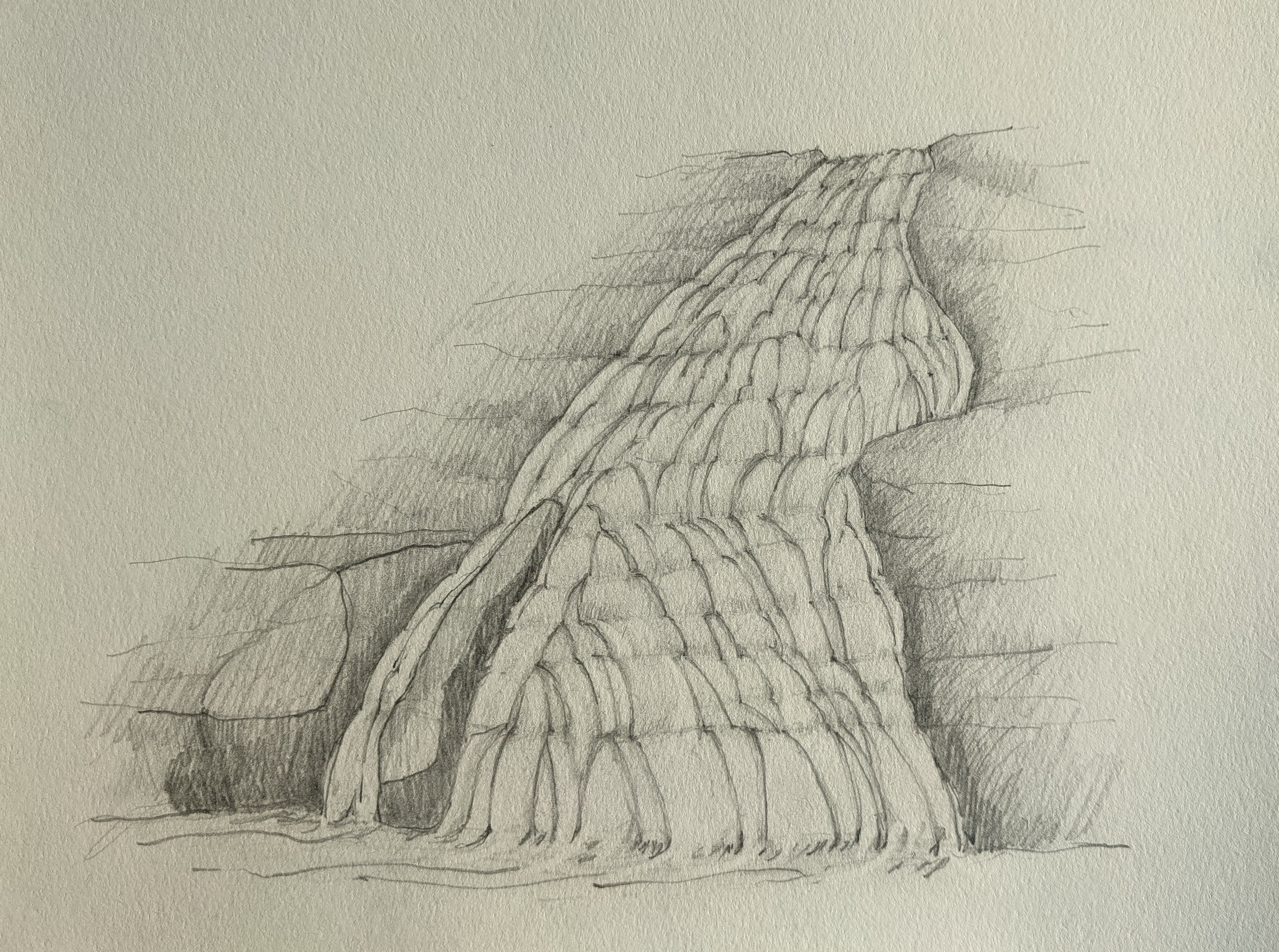 A fan waterfall is a steeper-angled cascade that is narrow at the top but then fans out as it falls toward a wider base. Fans are similar to horsetails but tend to look more trapezoidal, and the velocity of the flow is much slower. The slower speed creates a more pronounced fan effect as the water descends toward the base. |
 A cascade waterfall consists of a series of small drops along a slope with a low angle of descent. There are too many drops to actually count. |
(Thanks to our friend Jeff J. for his sketches of the various types of waterfalls.)
Here is a description of each of the waterfalls we have visited in the North Island.
Billy Goat Falls
 Description: Billy Goat Falls are officially the tallest in the North Island. Despite the fact that only parts of the waterfall can be seen and only at a distance, the falls are still very impressive.
Height: 180 m
Type: Multi-step
River/Stream: Atuatumoe Stream
Location: Kauaeranga Valley, Coromandel Forest Park
Distance from Hamilton: 126 km
Saturday 20 September 2021: After covering the first 100 km from Hamilton to Thames in the first hour on expressway and state roads, it took us nearly a full second hour to drive the 26 km up the Kauaeranga Valley Road to the very end. It was a beautiful drive, following the Kauaeranga River the whole way, much of it along a gravel road. At the end of the road, we parked our car, crossed the river on a fairly new walking suspension bridge, and hiked the 30 minutes to Billy Goat Landing where we got the best view of the falls we were going to get. Fortunately, we had brought a camera with a zoom lens. Even though it was only 1 km away as the crow flies, there was nothing but wild bush between us and the falls. We had planned to make the 2 hour hike up the mountain from the west to the top of the falls, but when we discovered that it meant traversing the river without a bridge, we decided that we would have to pass this time. It was still a little too cold and the water a little too deep to wade.
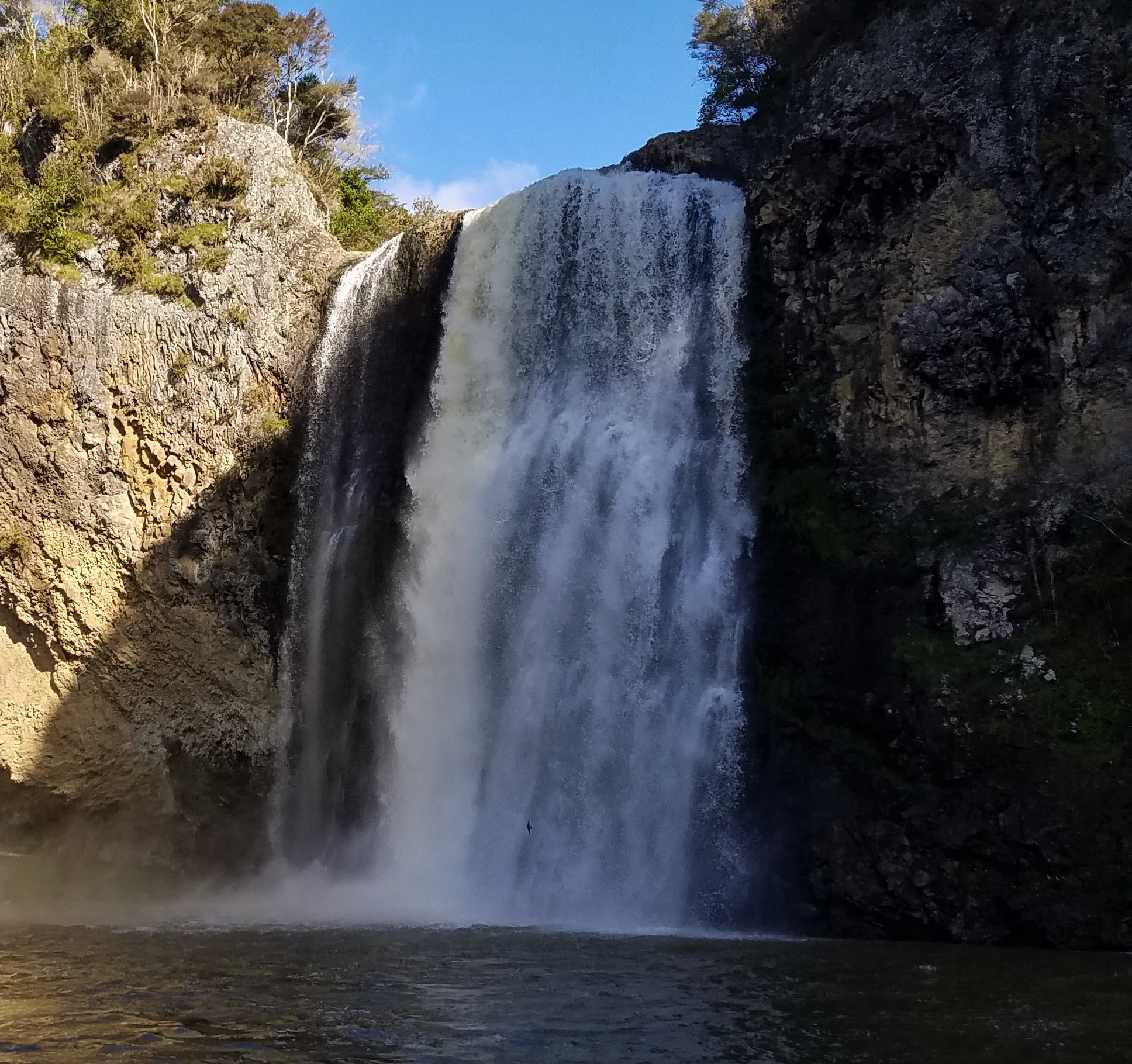
Bridal Veil Falls
 Description: A very tall and extremely powerful waterfall, Bridal Veil or Waireinga (Māori for “leaping spirits”) Falls is located in the northwest Waikato District. The spectacular setting and easy accessibility make Waireinga one of New Zealand’s favorite and most seen waterfalls.
Height: 55 m
Type: Punch bowl
River/Stream: Kaikai Stream
Location: Waireigna Reserve
Distance from Hamilton: 49 km
Sunday 12 January 2020: On our second day in New Zealand, we ventured out into the wild world of driving on the left hand side of the road, headed first to Raglan, considered by some the surfing capital of New Zealand, and then down the road to the Waireinga Reserve and the carpark for the falls. After a fairly easy 15-minute walk, we reached the lookout at the top of the falls. After another ten minutes down several steps, we reached the bottom and had an awesome view up the falls. Because it was a nice summer day and pre-COVID, we encountered lots of other people on the track. At that point, we did not realize how rarely that would happen again.
Hamilton Gardens Falls
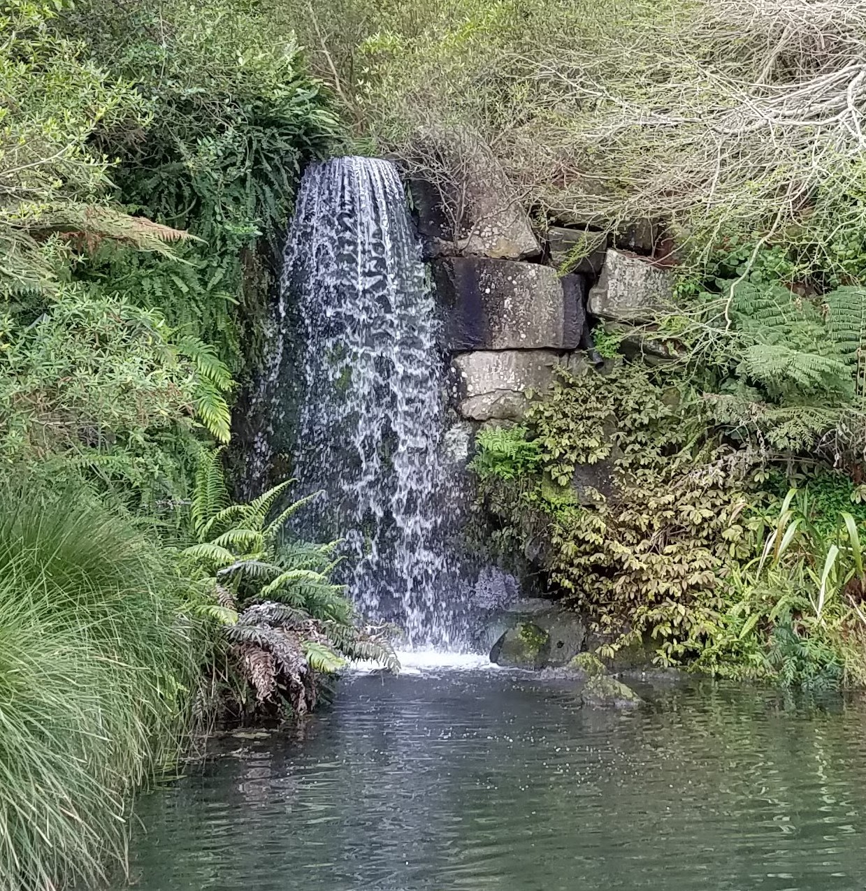
 Description: Hamilton Gardens, a public botanical park situated on the Waikato River on the south side of Hamilton, boasts the only waterfall within the city’s boundaries. Like the pond it falls into, the waterfall is man-made.
Height: 4 m
Type: Horse tail
Location: Hamilton
Wednesday 13 October 2021: Though we had been to Hamilton Gardens many times while living in the area for almost two years, we had never walked around the pond. On this particular visit, Hamilton and its environs were under Level 3 COVID restrictions, so we were working from home and couldn’t travel outside our district. Nevertheless, we had been encouraged to go outside for exercise, so one beautiful afternoon in early spring we drove to Hamilton Gardens. Even though the facility was officially closed and the specialty gardens gated, the main footpaths were unblocked, so we took the one that leads around the pond and past the waterfall.
Huka Falls
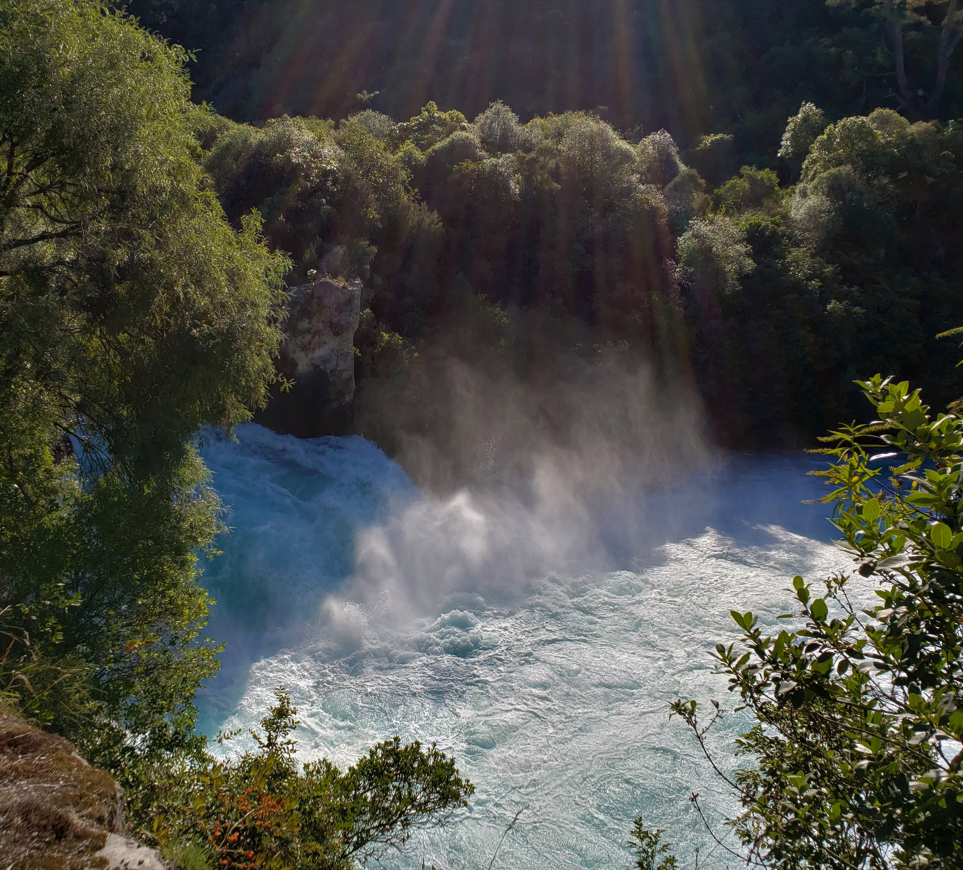
 Description: Located on the Waikato River only ten minutes from Taupo, Huka Falls is one of the most-visited natural attractions in New Zealand. What it lacks in height, it makes up in power, with a water flow of 300,000 liters per second. A major generating station is located a little farther downstream.
Height: 19 m
Type: Cascade
River/Stream: Waikato River
Location: Taupo
Distance from Hamilton: 149 km
Sunday 16 March 2020: The Waikato River, the longest river in New Zealand, has its beginnings in Lake Taupo. After we had been in New Zealand for a couple of months, Barry and Eva had to go to Hastings on business and proposed that we meet them in Taupo on their way back. Diane joined us for the Sunday drive, during which we stopped several times to visit sites along the way. Our last stop before meeting Barry and Eva at the hotel was at Huka Falls. The speed, power, volume, and turquoise color of the water were all amazing.
Hunua Falls
 Description: The Wairoa River carves through an ancient volcano in the Hunua Ranges as it winds its way north through Clevedon Township before meeting the Hauraki Gulf. Less than an hour’s drive from central Auckland, Hunua Falls flows into a nice, wide pool that’s a popular summer swimming area.
Height: 30 m
Type: Horse tail
River/Stream: Wairoa River
Location: Hunua Ranges Regional Park
Distance from Hamilton: 105 km
Monday 9 August 2021: After spending the morning of our day off shopping and cleaning our flat, we rewarded ourselves with an afternoon outing. The Hunua Ranges are southeast of Auckland, on about the same latitude as the airport but a world away. It was a very pleasant rural drive, with rolling hills and quaint farms. The falls are in a fairly open area and are easily accessible only ten minutes from the carpark by way of a level footpath. A nearby footbridge across the stream took us on a 30-minute loop to a lookout across from the top of the falls.
Lipsey Stream Falls
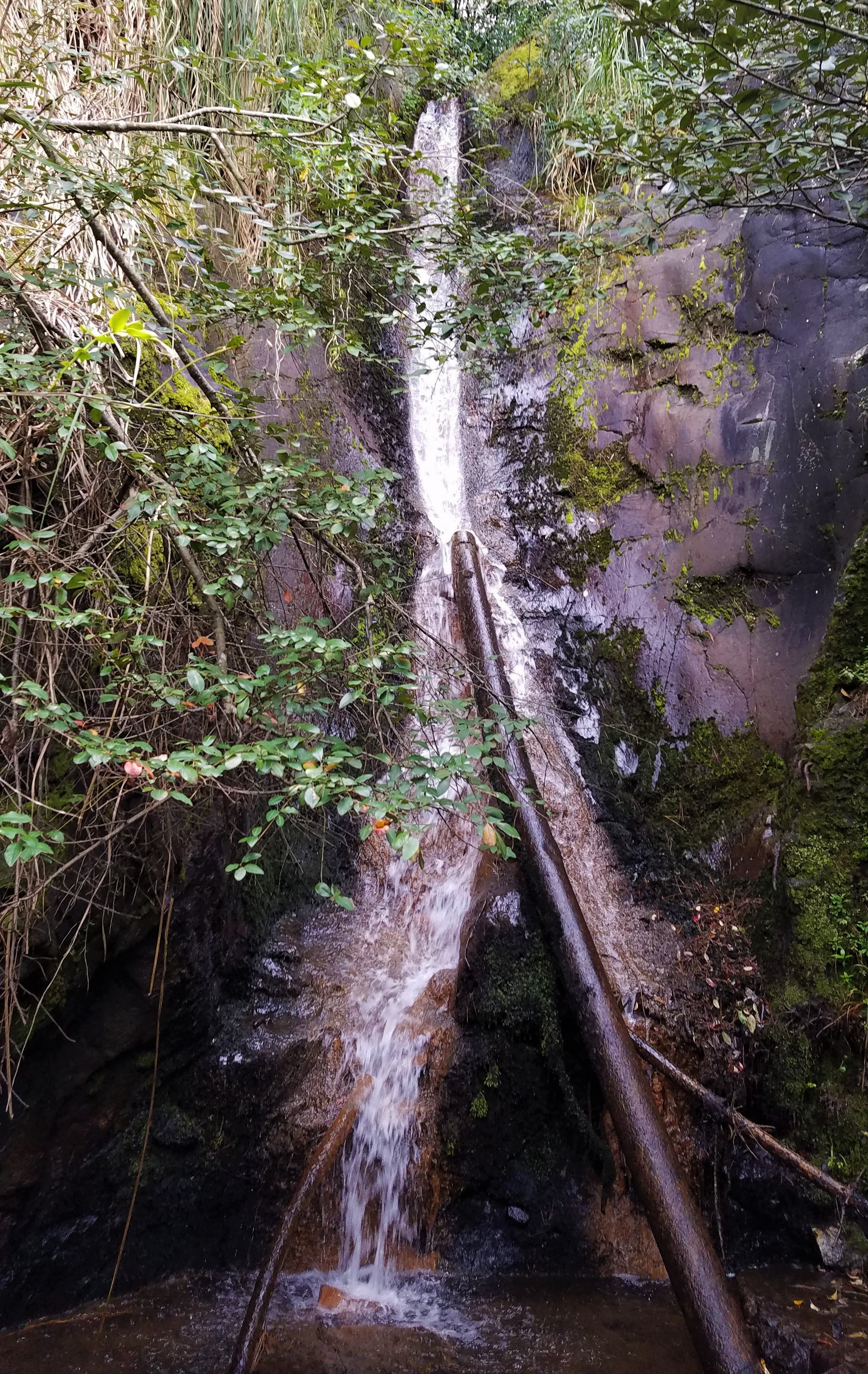
 Description: Also called Crusher Falls, these can be found via a 15-minute walk behind the Te Aroha Mineral Spas.
Height: 5 m
Type: Horse tail
River/Stream: Lipsey Stream
Location: Kaimai-Mamaku Forest
Distance from Hamilton: 59 km
Monday 13 September 2021: The Lipsey Stream Falls are not impressive enough to warrant a special trip on their own, but they constitute a bonus along the track to Tutumangaeo Falls (see below).
Marokopa Falls
 Description: Marokopa Falls are located in the Tawarau Forest, a few kilometers east of the popular Waitomo Caves. The falls are situated where the Marokopa River tumbles over greywacke basement rock about 10 kilometers before it reaches the Tasman Sea.
Height: 35 m
Type: Fan
River/Stream: Marokopa River
Location: Marokopa Falls Scenic Reserve
Distance from Hamilton: 97 km
Monday 17 February 2020: Visiting Marokopa Falls provided a nice finish to a full morning of tramping around Mangapohue Natural Bridge and Piripiri Caves. The Natural Bridge is what the Marokopa River has left intact after thousands of years carving a gorge through the limestone. The caves, though not as impressive as those in nearby Waitomo, are part of the same system. The carpark for Marokopa Falls is a little farther down the road from the Natural Bridge, and an easy 15-minute hike takes you to a large viewing deck across the river from the base of the falls. We had left Hamilton shortly after breakfast in company with Barry and Eva, and enjoyed a picnic lunch together in Waitomo before heading home.
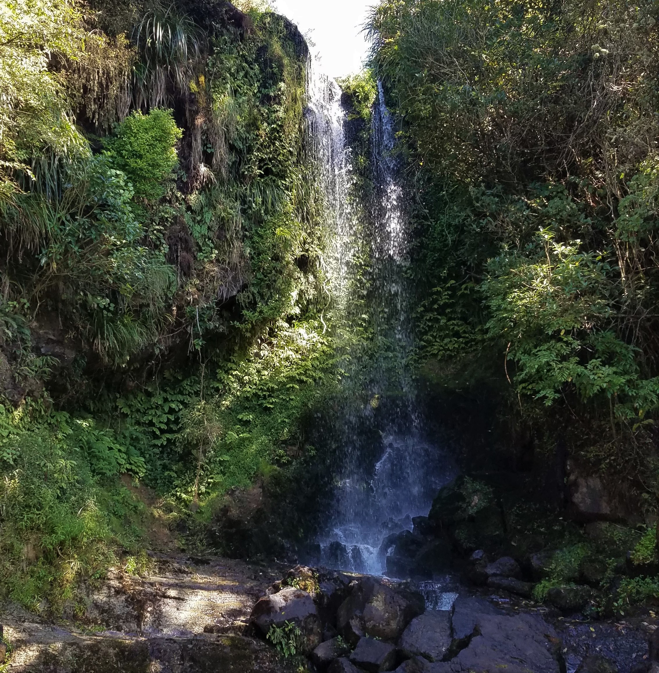
Omaru Falls
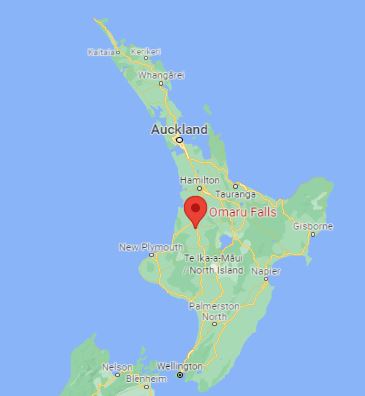
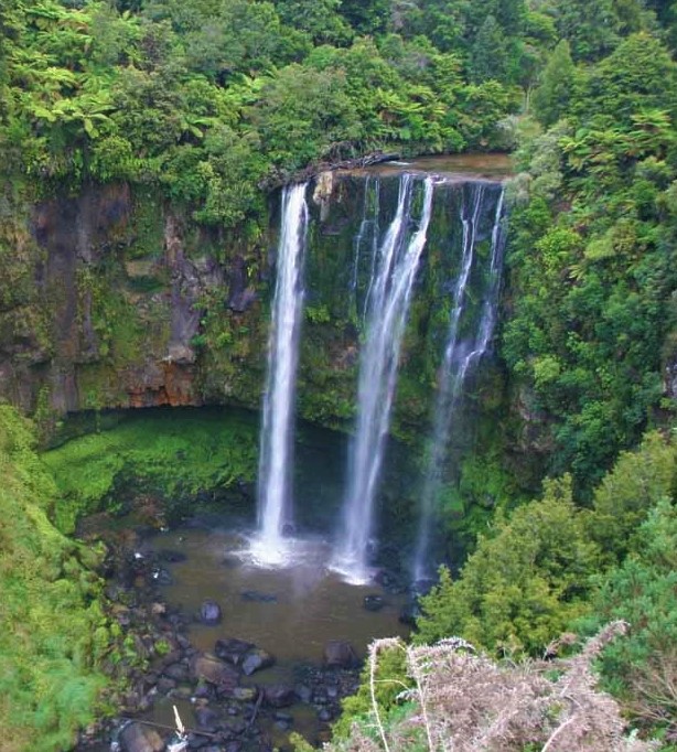 Description: A classic curtain waterfall, Omaru Falls is located south of Te Kuiti. The waterfall’s base is inaccessible, surrounded by dense bush in a deep ravine.
Height: 45 m
Type: Curtain
River/Stream: Mapiu Stream
Location: Kutukuru Scenic Reserve
Distance from Hamilton: 109 km
Monday 26 April 2021: We made this full-afternoon trip with Wendy and Alan. The hike in and out through paddocks and bush was fairly easy, but took us nearly three hours because we spent time identifying plants and birds along the way (as one does when tramping with Wendy and Alan). To see the falls, we had to climb about fifty steps up to a viewing platform across the ravine. Although the falls were maybe half a kilometer away, we had a pretty decent view—enough tor us to appreciate their beauty and power. We tried to find a way to get a closer view but were unsuccessful.
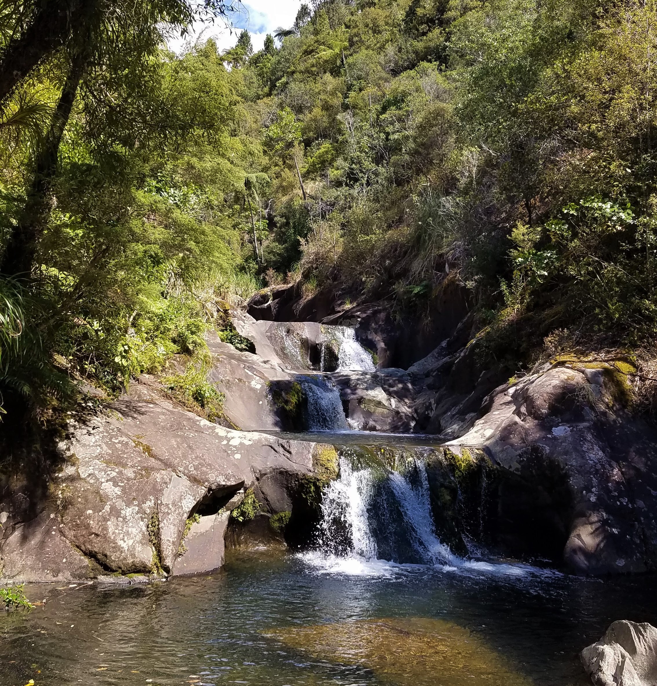
Owharoa Falls
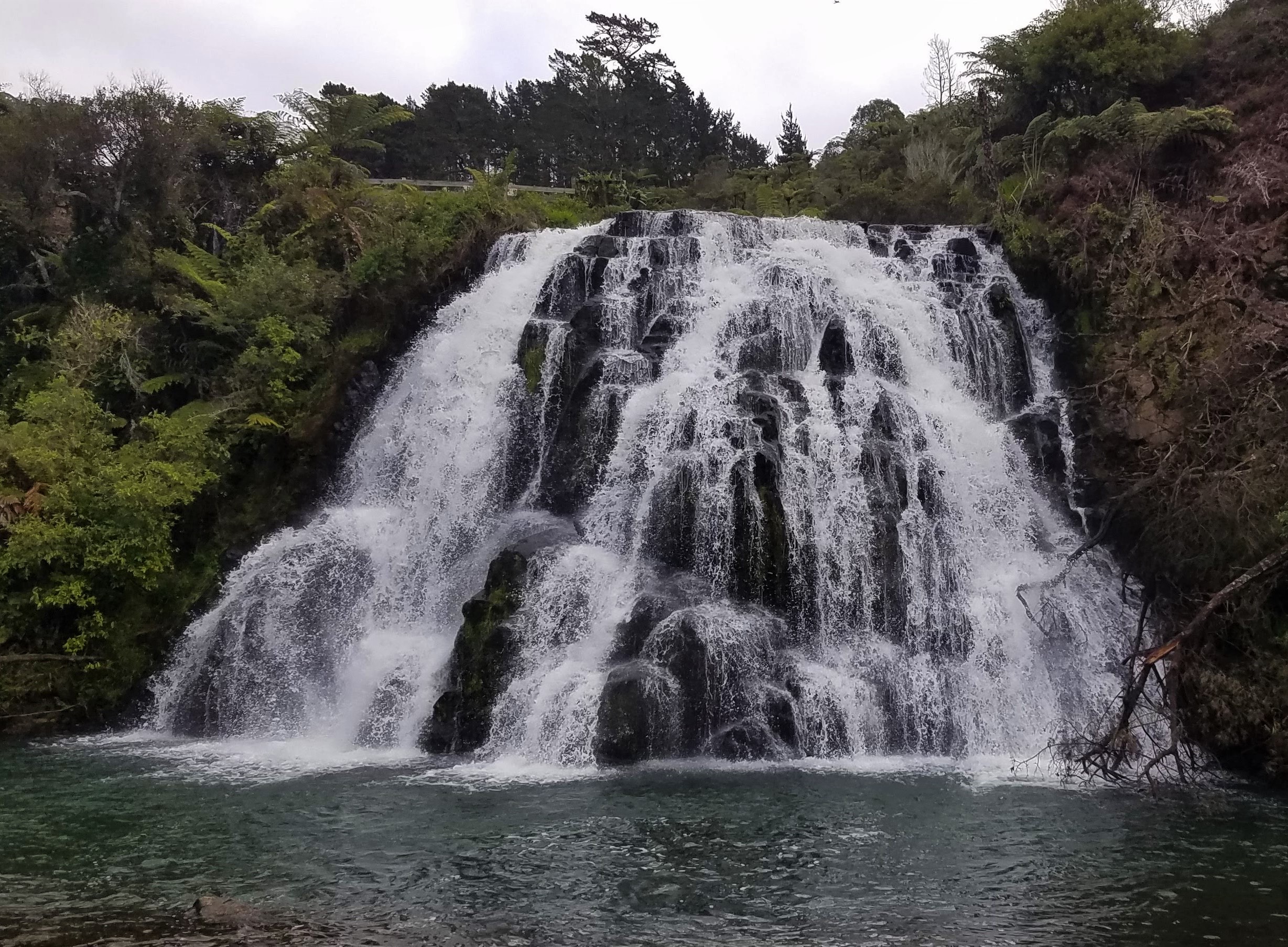
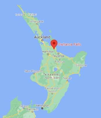 Description: Actually a series of three waterfalls, Owharoa Falls are a couple of kilometers away from the popular Karangahake Gorge. The first and third waterfalls are easily accessible, but only the top of the second one can be seen from the road.
Height: 6 m
Type: Fan
River/Stream: A tributary of the Ohinemuri River
Location: Karangahake Gorge
Distance from Hamilton: 87 km
Monday 31 August 2020: This is another waterfall that is not impressive enough to merit a special trip. It does however, provide a perfect way to end a few hours hiking in the gorge. One begins the trek by walking a full kilometer through a railroad tunnel that was used in the late 19th century to transport gold out of the mountains. Once you emerge from the tunnel, you follow the track along the river, and finally past a series of abandoned gold-processing facilities. We’ve hiked the gorge twice: first with Barry and Eva, and then with Alan, Wendy, Diane, and Doug and Deonne L (another senior missionary couple who were responsible for teaching self-reliance courses in the Hamilton area). Owharoa Falls is a 5-minute drive from the tunnel.
Seven Stairs to Heaven Falls
 Description: The Seven Stairs to Heaven Falls are part of the Rapaura Watergardens, a 64-acre private estate in the middle of the Coromandel Peninsula.
Height: 15 m
Type: Multi-step
Location: Raparua Watergardens
Distance from Hamilton: 132 km
Monday 20 January 2020: After just ten days in New Zealand, we took our first 100-plus kilometer trip to the Coromandel Peninsula. We had been told that the Rapaura Watergardens were worth a visit, and we were not disappointed (although the abundant rhododendrons were no longer in bloom). Rapaura’s owners have created a series of outdoor spaces connected by meandering footpaths and bridges where human creativity complements native flora and the landscape. The Seven Stairs to Heaven multi-step cascade is the highlight of a loop through a section of natural bush at the back of the Watergardens.
Tawarau Falls
 Description: The falls are some of the most remote in the North Island, nestled in the midst of the forest southwest of Waitomo Caves. A challenging two-hour tramp through dense bush is required to see them.
Height: 25 m
Type: Cascade
River/Stream: Tawarau River
Location: Tawarau Forest
Distance from Hamilton: 87 km
Wednesday 20 October 2021: We had anticipated that this would be the most remote waterfall we had sought out yet, and we were not wrong. The road beyond the Waitomo Caves Visitors Centre (which was closed due to COVID restrictions) was only lightly traveled that day, and once we turned off the paved road the only living creatures we saw besides the usual birds and bugs were some very startled sheep. Turning off the pavement meant inching carefully along a very rough, one-lane gravel track through a mixture of bush and rolling grass-clad hills. After we had driven about 2 km, trying to dodge myriad water-filled potholes, we noticed that the “you are here” arrow on our GPS screen was untethered to any road at all; indeed, other than the arrow, the screen was blank. After another 2 kilometers, creeping along at 5 km per hour and wondering how much longer our trusty Toyota Corolla would have to take such a beating, we finally we reached a sign indicating that the Tawarau Falls Track was just ahead, near a spot with enough room to park. Now we could begin the two-hour tramp on a foot track that obviously saw little use. Nancy had picked up a couple of sturdy sticks near the trailhead to use as hiking poles, and boy, was she glad she had them!
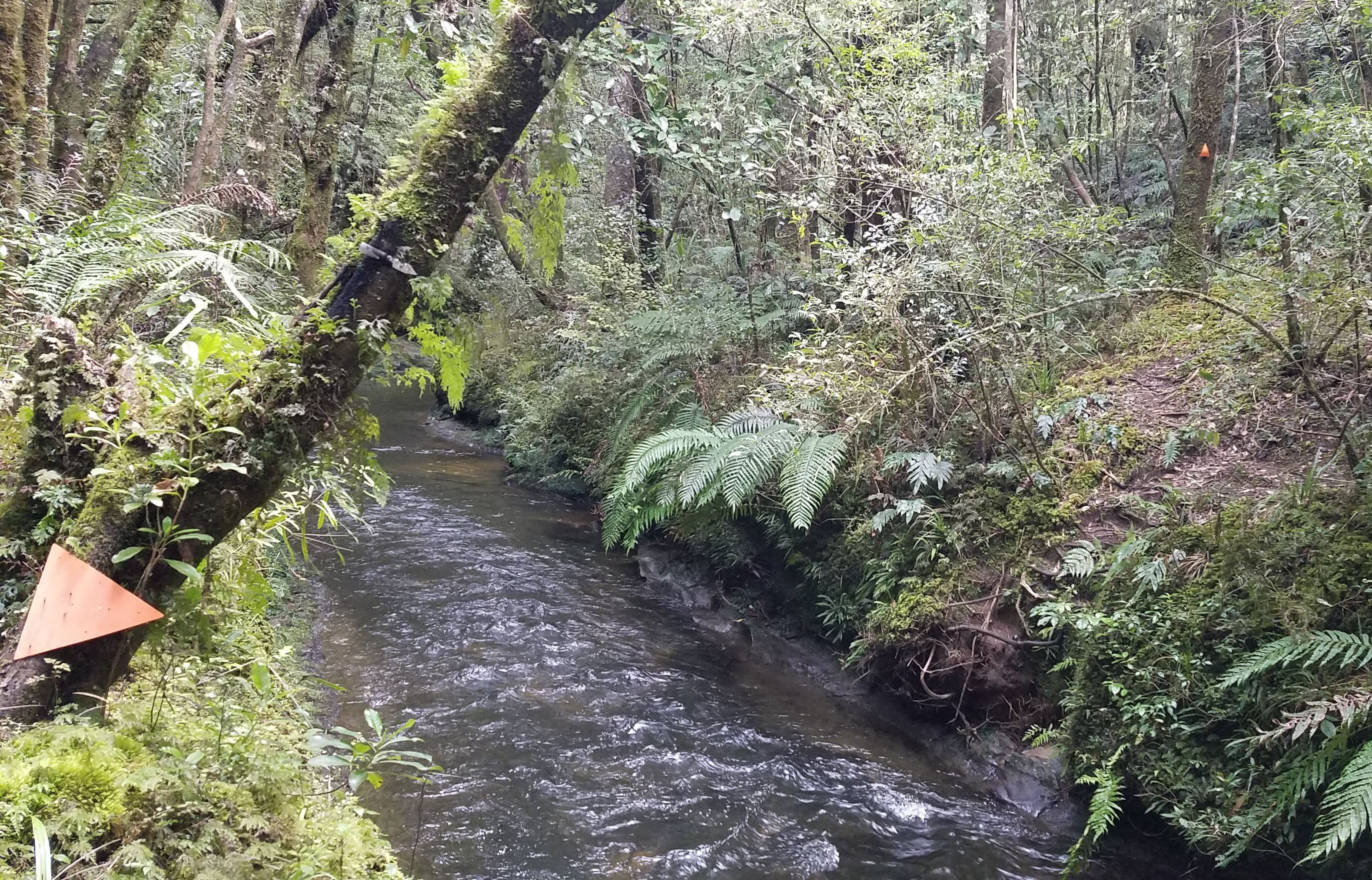
The next trail marker after the one at the left is on the tree at the far right, so the only way to stay on the track is to ford the river
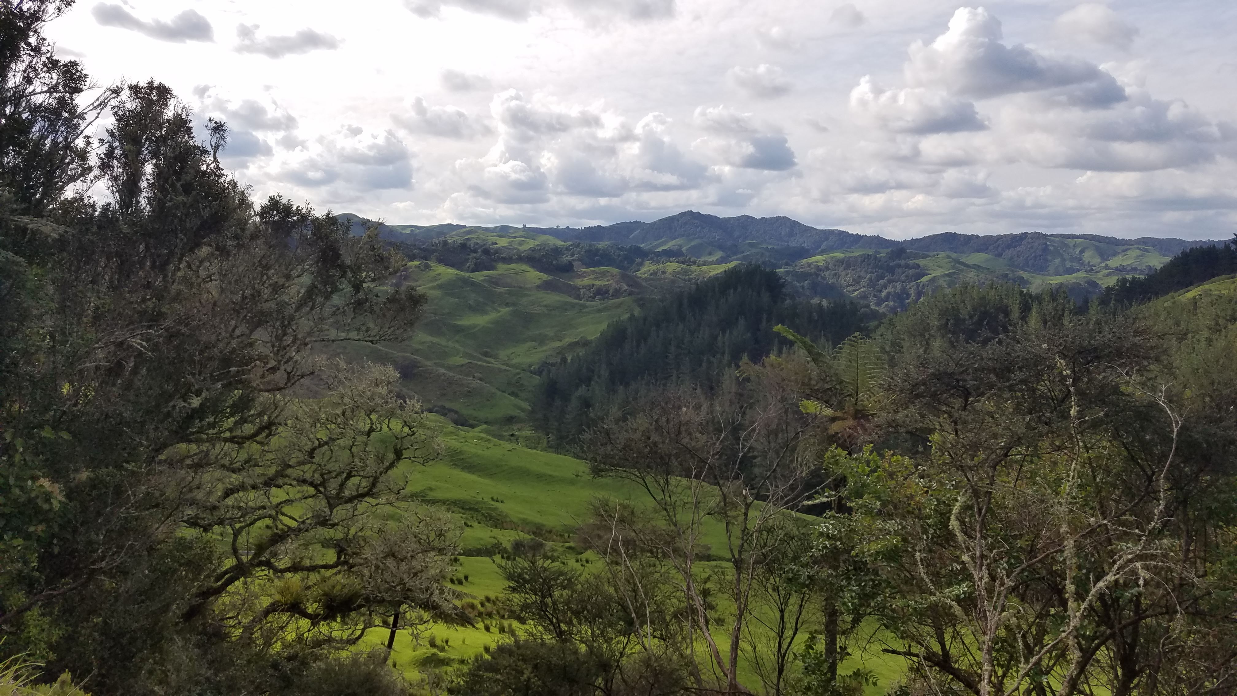
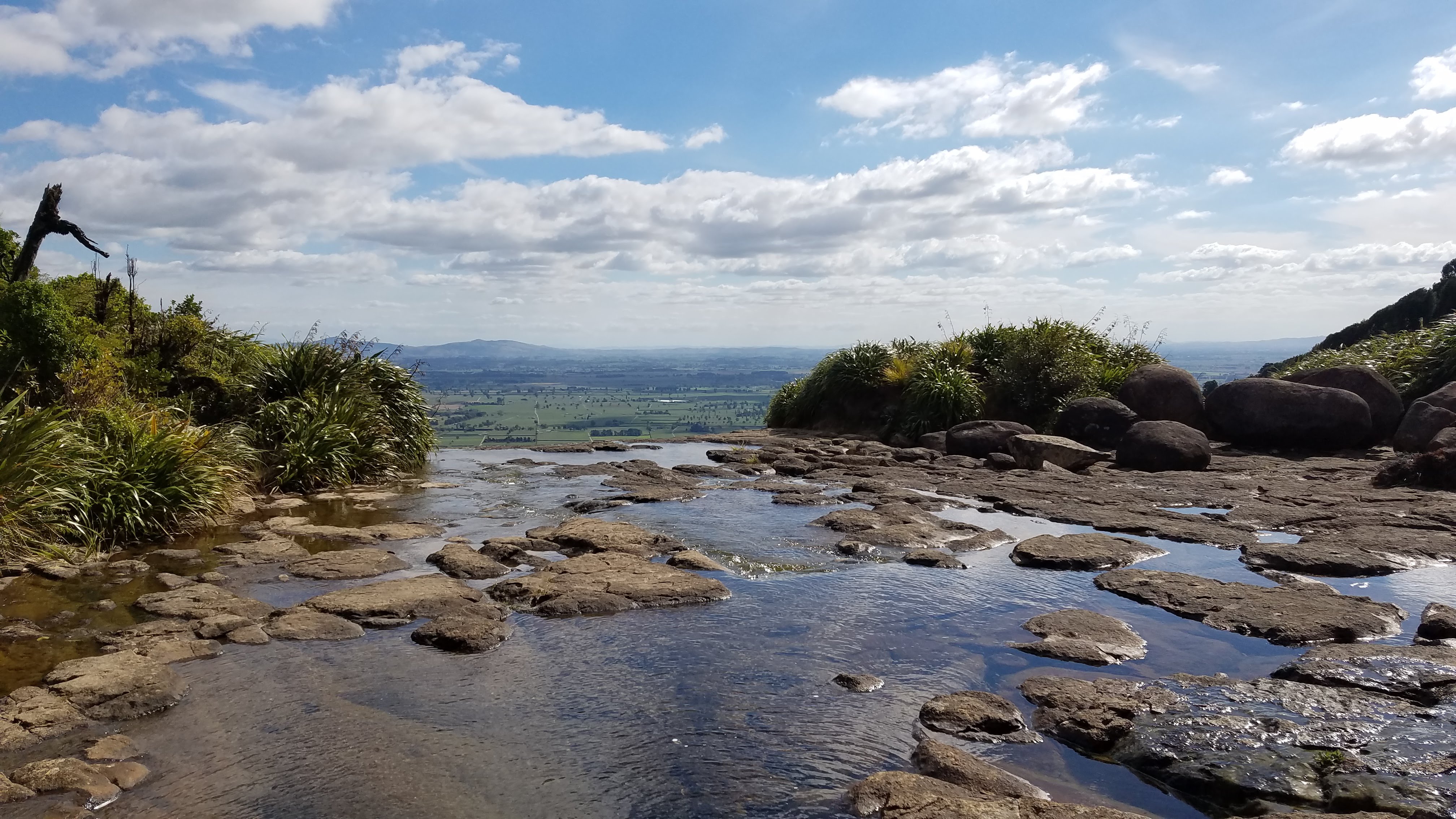
We may have missed the falls, but we did not miss the vistas along our way to the forest reserve
The track required a lot of clambering up and over slippery rocks and exposed roots, then down into muddy troughs where the footing was too unstable to allow one to leap across. For much of the way, the trail stayed near the riverbank, but then it turned uphill into denser bush. After we’d hiked for about an hour, the path seemed to peter out and we realized that we hadn’t seen any trail markers for a while, so we backtracked to the last marker we had seen, right next to the river. To our dismay, we now saw that the slightly askew arrow pointed across the river, and sure enough, there was another red arrow on the other side of a rushing stream that was knee-deep and at least eight feet wide. We had not come prepared to get soaked, so for the second time in our quest to see as many waterfalls as possible–feeling that we were already pushing our luck by traveling so far into an area with no cellular service without having told anyone where we were going–we turned around and went home. During the 22 minutes it took to drive 4 km back to the paved road, we were amused that the speed limit posted on our GPS screen for the last half of the gravel road was 100 km per hour. (As if!) Even though we never got to see Tawarau Falls, we had an unforgettable wilderness experience, and enjoyed some spectacular scenery in the process.
Tutumangaeo Falls
 Description: Located in Te Aroha Domain at the edge of town, the falls can be reached by following the Tui Domain Track uphill, on its way to the summit of Mount Te Aroha. At 952 m, Te Aroha is the highest point in the Kaimai-Mamaku range.
Height: 18 m
Type: Horse tail
River/Stream: Tutumangaeo Stream
Location: Kaimai-Mamaku Ranges
Distance from Hamilton: 59 km
Monday 13 September 2021: On our first trip to Te Aroha, we climbed about an hour along the Tui Domain Track to Collins Lookout but didn’t have time to go on to the falls. This time we made sure to get an earlier start. We discovered that the trail to the falls follows the Tui Domain Track for only ten minutes or so and then cuts off into the bush. The secondary trails in the Te Aroha Domain are not as well marked as the primary ones, so we had to do a little extra wandering to reach our destination, but once we found the falls we were glad that we hadn’t given up.
Vivian Falls
 Description: Vivian Falls are hidden in a ravine within a private reserve of natural bush surrounded by farmland near the village of Onewhero. A short footpath from the carpark leads to a good view.
Height: 12 m
Type: Horse tail
River/Stream: Kaipo Stream
Location: Harker Reserve
Distance from Hamilton: 91 km
Monday 15 March 2021: On our way to the beach at Port Waikato with Diane, Wendy, and Alan, we took a short detour to see Vivian Falls. The secluded, peaceful setting seems incongruent with the story behind the falls’ Māori name: Te Wai Heke O Maoa (Maoa Falls). Maoa was a Māori chief who lived in the area in the 1700s. After another chief named Tapaue killed and ate the brother of Maoa’s friend Te Ruinga, Maoa decided to lead a rebellion against Tepaue. To test the mettle of the warriors who were to accompany him into battle, Maoa ordered his men to dam the stream at the top of the falls and then go lie in the pool below. Once they were in position, he released the falls. Maoa knew he could rely upon the men who didn’t flinch when the water crashed over them.
Waiau Falls
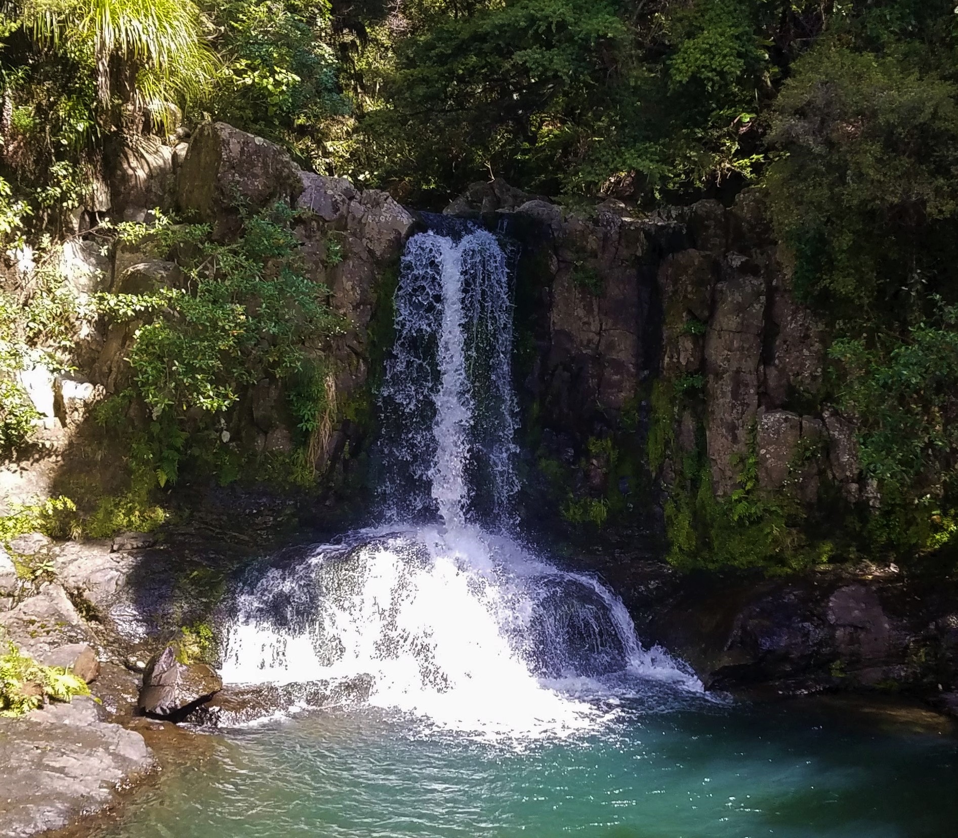
 Description: Right beside the road is a beautiful bush glade where the Waiau Falls spill over a rock face into a pool that’s perfect for swimming. Tracks both upstream and downstream of the falls provide access.
Height: 6 m
Type: Horse tail
River/Stream: Waiau River
Location: Waiau Scenic Reserve
Distance from Hamilton: 165 km
Monday 26 October 2020: On our second trip to the Coromandel Peninsula, we accompanied Barry and Eva on a drive up the east coast, on the Pacific Ocean. We walked along Hot Water Beach, then drove up to Whitianga for lunch. To return home, we decided to cut across the peninsula on Route 309, a 22 km gravel road that would take us past Waiau Falls. (Although it was gravel, Route 309 was not nearly as rough as the road to Tawarau Falls.) We hadn’t gone prepared to swim, so we didn’t.
Waipunga Falls
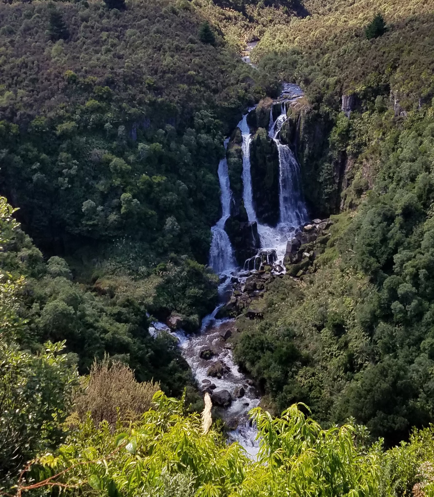
 Description: This is a classic example of tiered falls, with three separate drops. The falls are easily seen from the road. Not as easily seen is a companion waterfall, the Waiarua, which is to the left and shares the same pool at the bottom.
Height: 40 m
Type: Tiered
River/Stream: Waipunga River
Location: Waipugna Falls Scenic Reserve
Distance from Hamilton: 203 km
Monday 8 February 2021: On our way home from a multiple-day trip to the Hawkes Bay area with Diane, Wendy and Alan, Wendy pointed out the turnoff to Waipunga Falls, roughly halfway between Napier and Taupo on Route 1. If she hadn’t been with us, we would have missed the turn because there was no sign facing the northbound side of the highway. The carpark and viewing area are not far from the road, and the falls are definitely worth a stop.
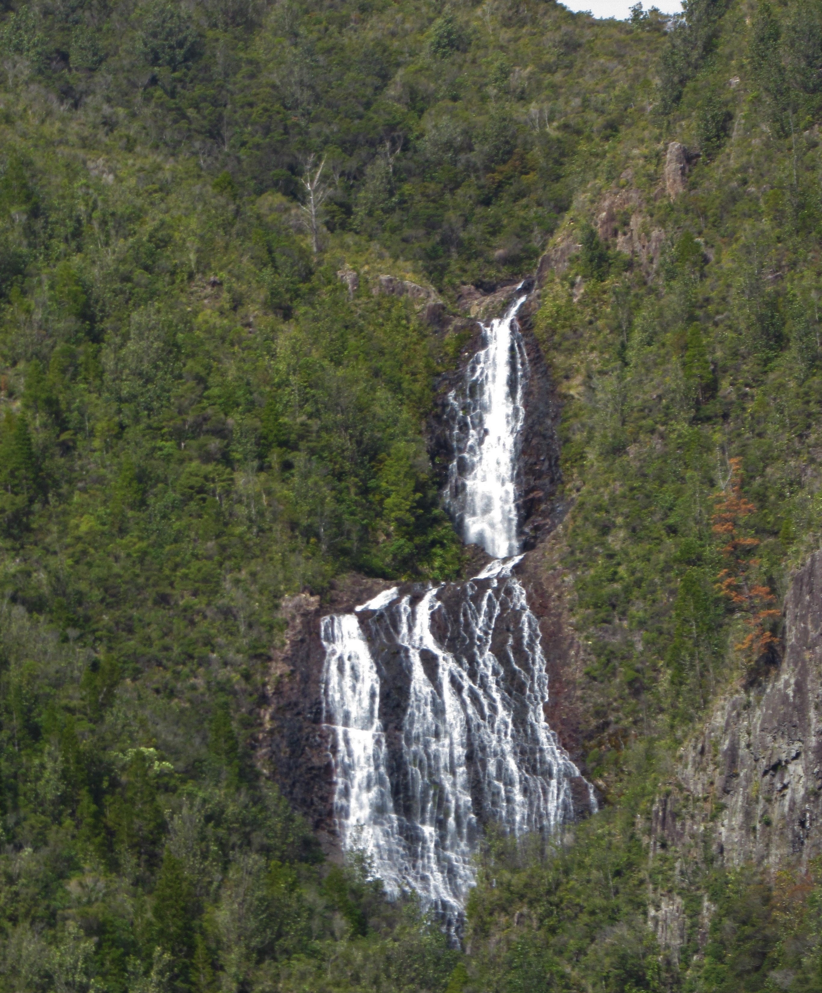
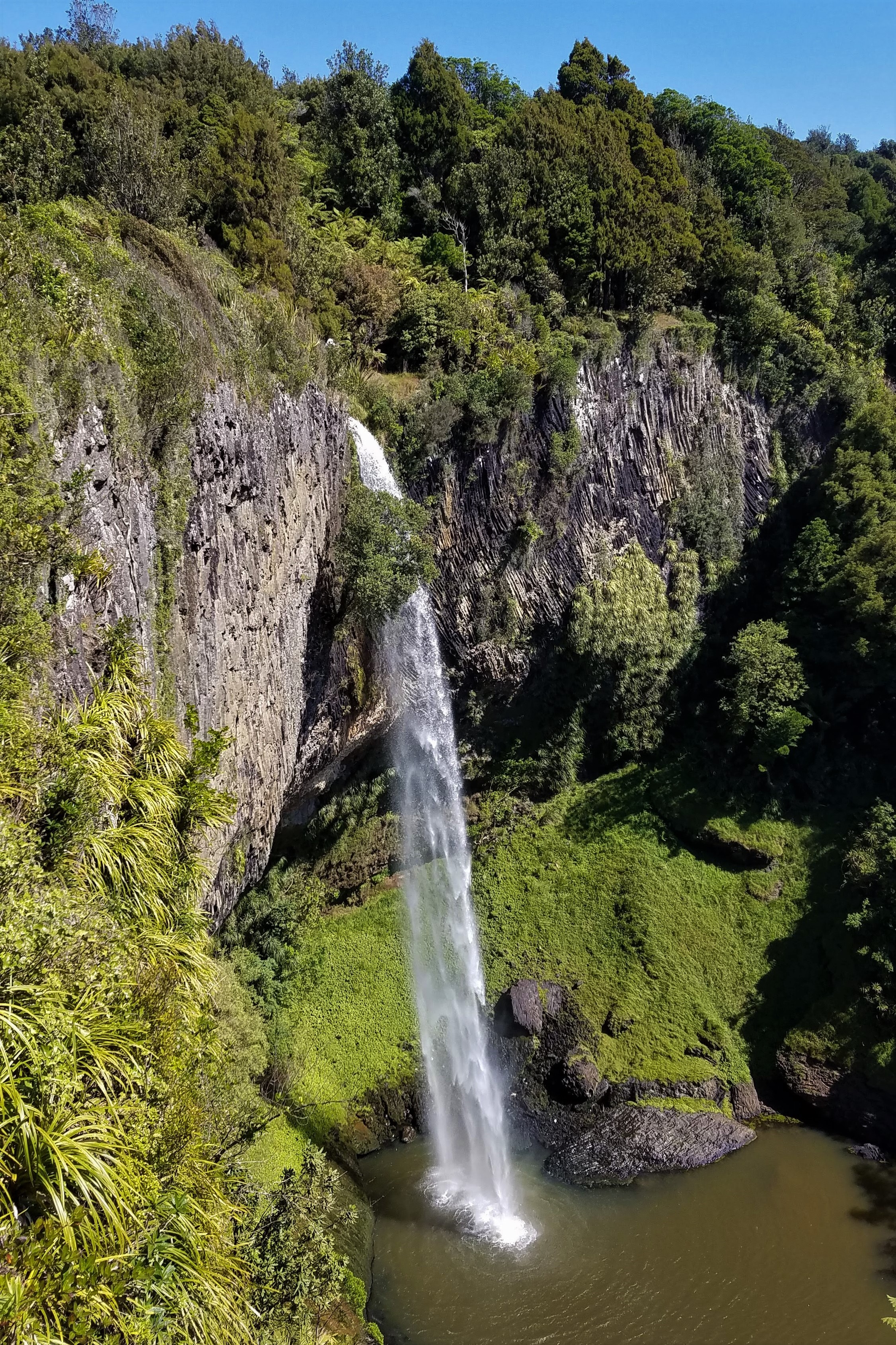
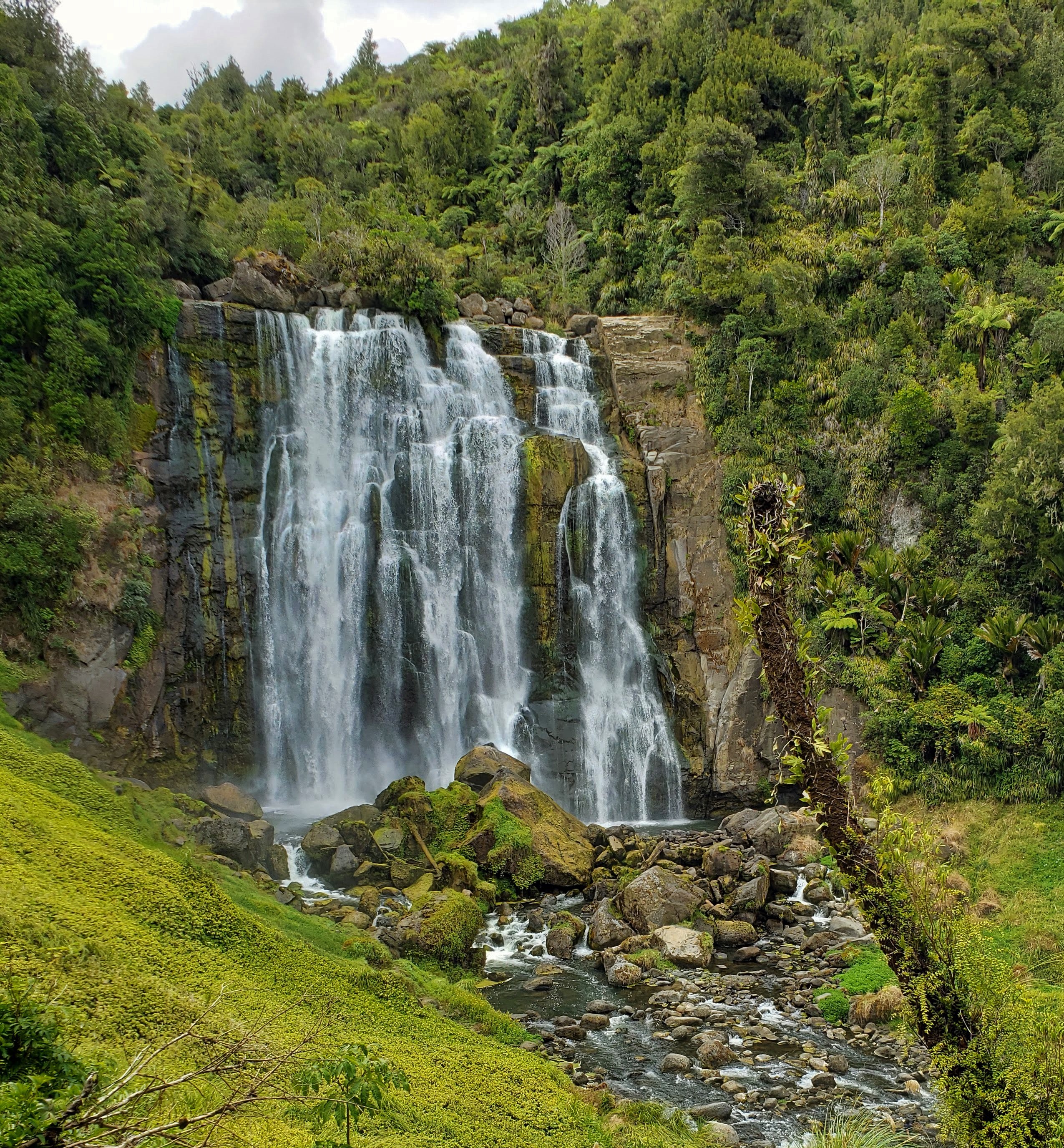
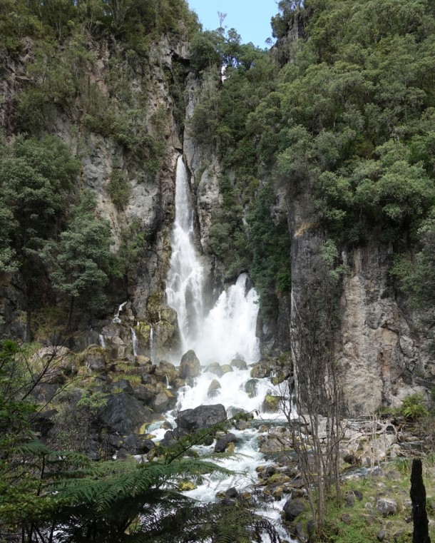
Wairere Falls
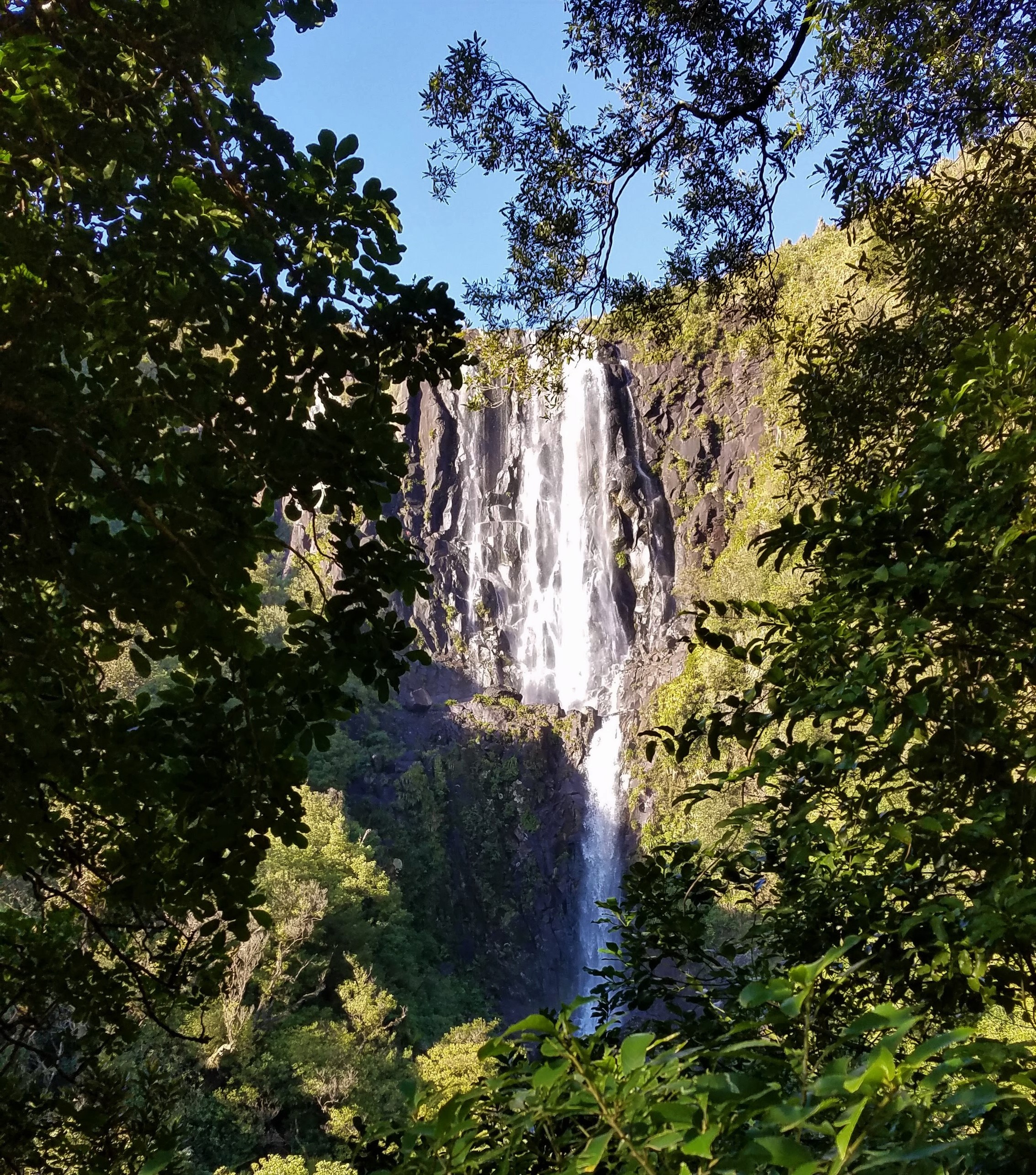
 Description: One of the tallest and most attractive waterfalls in the North Island, Wairere Falls is located in the Kaimai Range, which separates the Waikato region from the Bay of Plenty. The falls can be seen in the distance from State Route 27; however, the most impressive view is from a platform in the bush about halfway along the 5k Wairere Falls Track. From there, the track becomes much steeper before reaching the river at the top of the escarpment.
Height: 153 m
Type: Multi-step
River/Stream: Wairere River
Location: Kaimai Range
Distance from Hamilton: 70 km
At the summit, the Wairere River is surprisingly placid before it plunges over the precipice at the center of this photo
Monday 25 July 2020: On our first trip to Wairere Falls, we went with Barry and Eva and hiked 45 minutes to the viewing platform, which is the only place along the track where you can actually see the falls. The tramp offers a nice variety of scenery and is challenging enough to make you feel like you’ve accomplished something without being totally wiped out.
Monday 22 March 2021 On our second trip, we went with Wendy and Alan, and left earlier so we could do the 3-hour hike up to the summit and back down. The terrain at the top of the falls was not at all what we expected. The river is wide but surprisingly shallow, and the water flows so gently before plunging over the 153-meter cliff that we could stand in the middle of it only a few meters from the edge without fear of being swept away. And what a vista! We could see nearly the whole of Waikato spread out before us. This tramp was one of our all-time favorites.
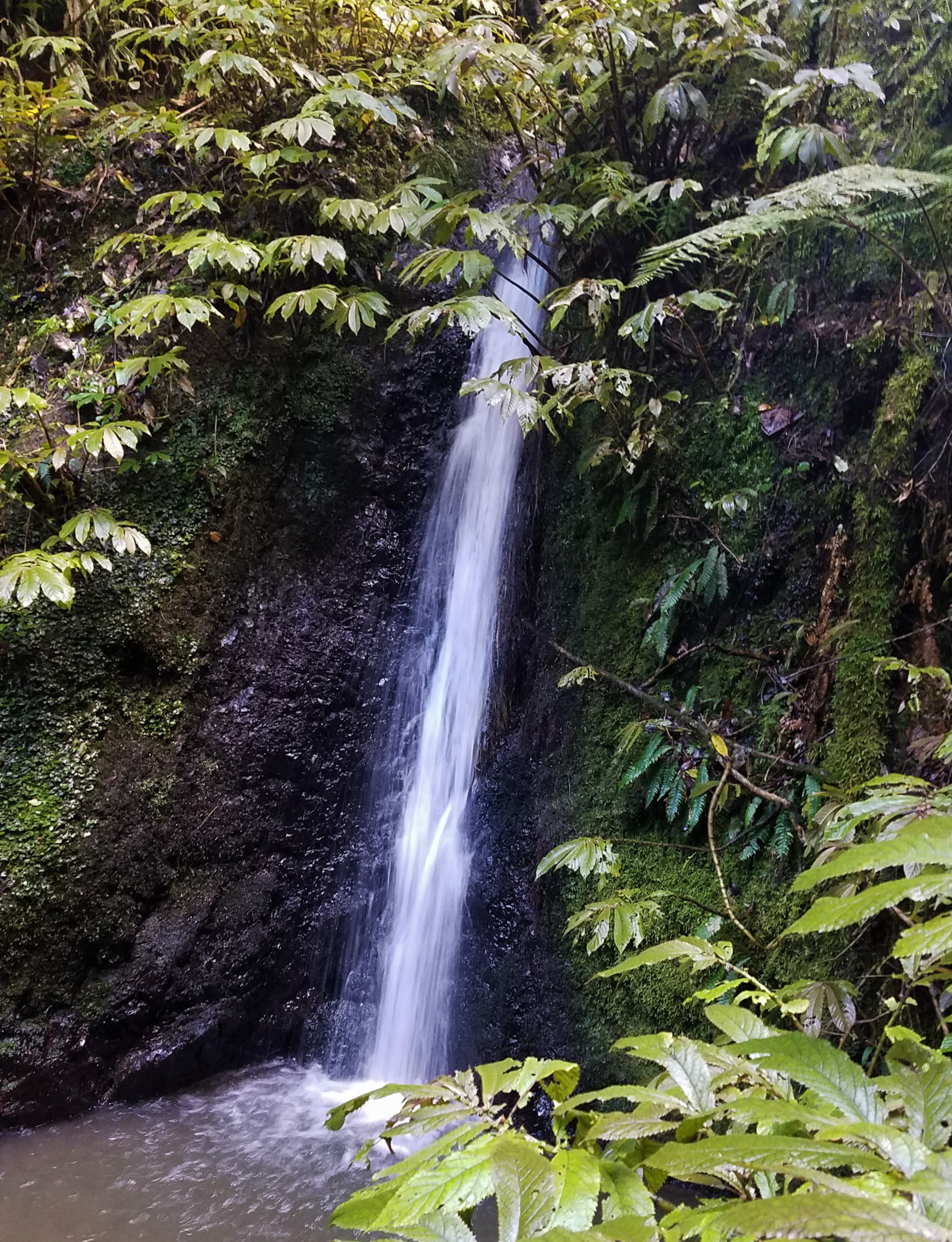
Waitanguru Falls
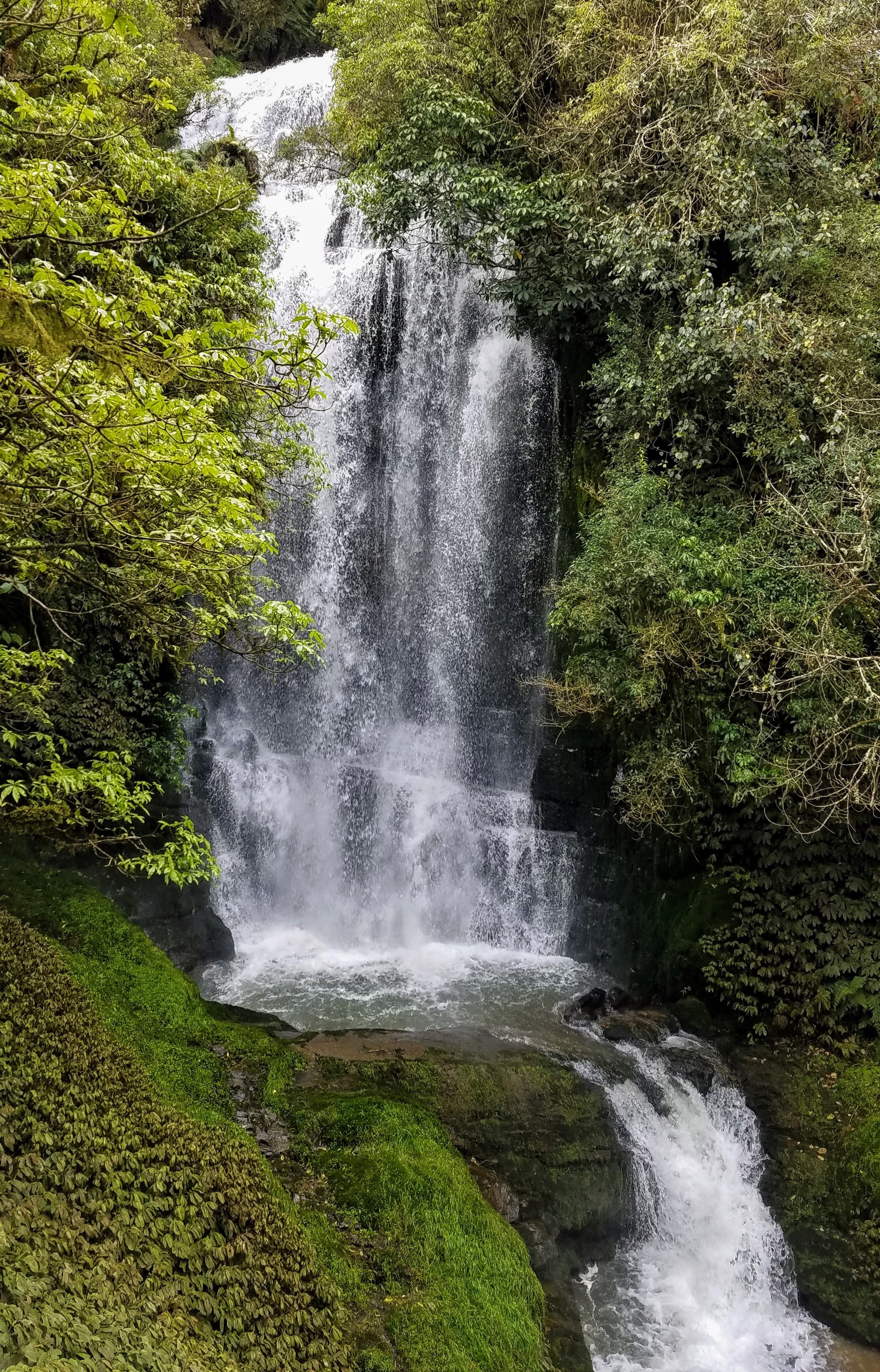
 Description: Waitanguru Falls is located in a scenic rural area between Te Kuiti and New Plymouth. An easy 15-minute walk from the carpark, mostly down well-maintained stairs, provides a close-up view.
Height: 15 m
Type: Plunge
River/Stream: Waitanguru Stream
Location: Mangaotaki Scenic Reserve
Distance from Hamilton: 118 km
Monday 27 September 2021: One might question whether a single waterfall could justify almost four hours of riding in the car, especially when the hike in and out didn’t provide much aerobic exercise, either, but these falls were definitely worth the drive. The viewing platform for the falls is in a cozy hollow surrounded by vegetation in every possible shade of green. From the number of fallen branches and undisturbed leaves on the track, we surmised that not many people actually visit these falls, which is a pity. The drive through the Mangaotaki Scenic Reserve offers splendid views, including some really interesting rock formations that were featured in The Hobbit film as “Trollshaws,” and even in the more populated areas we were treated to glorious displays of ornamental cherry trees in full bloom. Diane accompanied us on our journey, which made the drive more fun. Besides, Diane likes to try new restaurants as much as we do, so we timed our trip such that we could stop for dinner at the Redoubt Bar and Eatery in Te Awamutu on our way back to Hamilton.
Waterworks Falls
 Description: Several small waterfalls can be seen along the Waterworks Walk up to an old reservoir, built in 1925 to supply water to the town of Ngaruawahia. The reservoir was replaced in 1965, so now water just spills over the old dam.
Height: 5 m
Type: Cascade
River/Stream: Mangarata Stream
Location: Hakarimata Scenic Reserve
Distance from Hamilton: 20 km
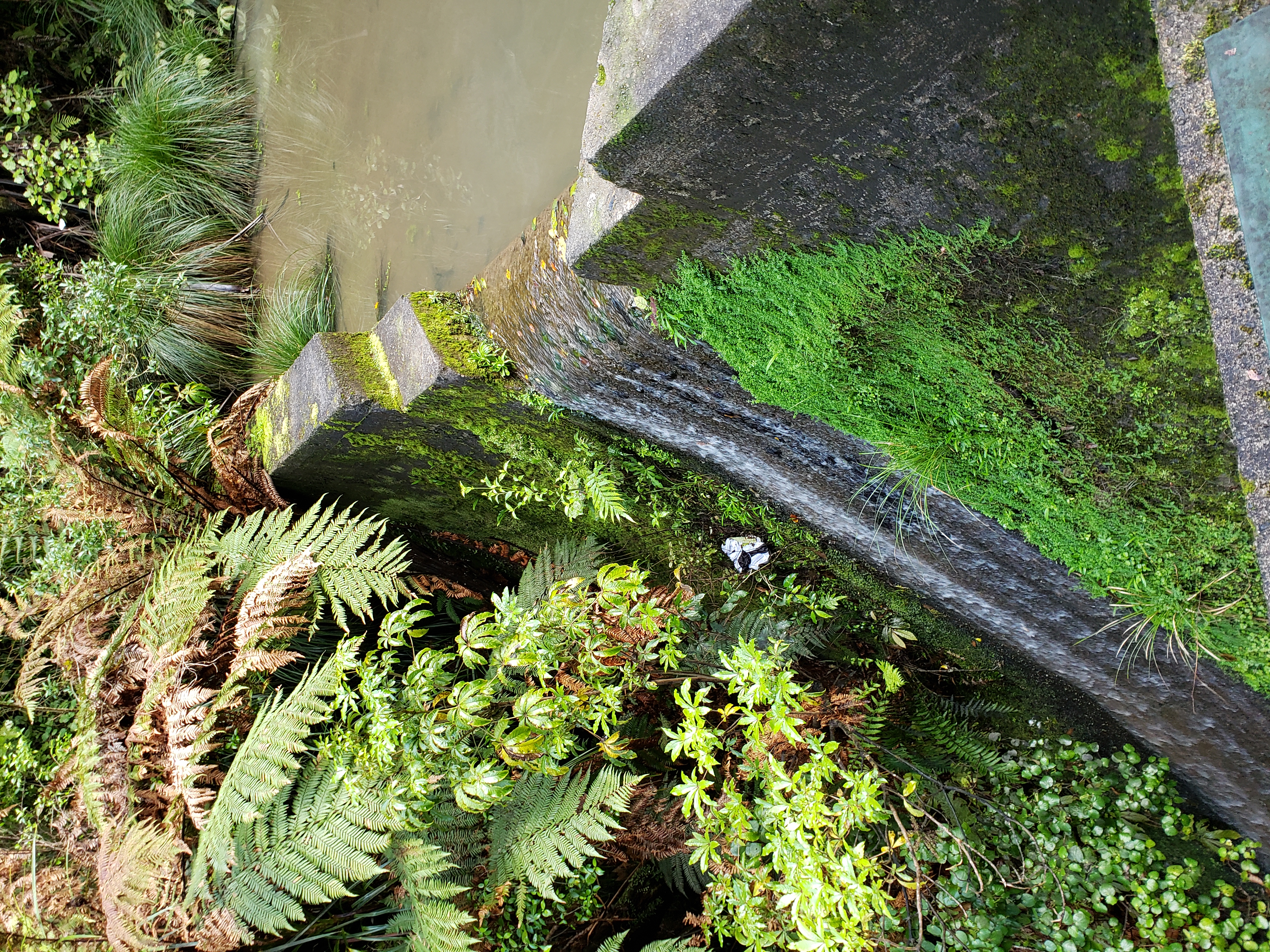
Spillway over the old waterworks dam
Monday 7 September 2020: Ngaruawahia is only a 30-minute drive from where we live. Barry and Eva picked us up around 2:00 p.m., and after the short drive and the fairly short walk, we felt like we still had a lot of afternoon ahead of us. So Barry, who was driving, made an “executive decision” to head north along the Waikato River toward Pokeno so we could get some ice cream. Why Pokeno? Two virtually identical, side-by-side dairies in this little town both serve gigantic scoops of ice cream for only $2 ($2.50 in a waffle cone), so a stop in Pokeno has become a must-do for any missionary traveling between Hamilton and Auckland on Route 1.
You must have worn out at least one pair each of hiking boots! What a splendid theme for your excursions. You have certainly taken every advantage of your time in NZ to see all that it has to offer.
Waterfalls are among my favorite landscape features, and I think it’s great that you sought them out for an intermittent waterfalls tour. We once did the same in Colorado. It’s hard to choose a favorite, but from the photos I think I like Waitanguru Falls the best. You could choose your 12 favorites and make a calendar–I usually choose a waterfalls calendar for the kitchen wall each year. Thanks for this post and all of them.